


TOP 03

aldaus
User
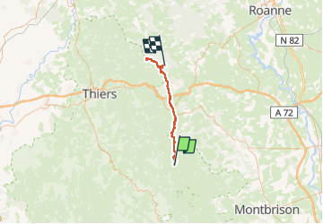

Length
41 km

Max alt
1386 m

Uphill gradient
998 m
Km-Effort
56 km

Min alt
664 m

Downhill gradient
1414 m
Boucle
No
Creation date :
2024-07-09 04:29:36.031
Updated on :
2024-07-10 13:12:57.832
9h36
Difficulty : Medium

FREE GPS app for hiking
 SityTrail
IGN / Geographical institutes
SityTrail Plus
The world is yours!
About
Trail Walking of 41 km to be discovered at Auvergne-Rhône-Alpes, Puy-de-Dôme, Le Brugeron. This trail is proposed by aldaus.
Photos


Positioning
Country:
France
Region :
Auvergne-Rhône-Alpes
Department/Province :
Puy-de-Dôme
Municipality :
Le Brugeron
Location:
Unknown
Start:(Dec)
Start:(UTM)
560598 ; 5061346 (31T) N.
Comments